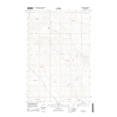
2014 Map of Becker Dam
USGS Topo · Published 2014About this map
The Big Sheep Mountains dominate the western horizon of this Prairie County landscape, where the high plains are carved by a complex network of ephemeral drainages. Water management in this arid region is anchored by Becker Dam and the nearby Ban Reservoir Number 1, essential infrastructure for local ranching operations. The terrain is defined by deep cuts like Smith Coulee and Timber Coulee, which channel runoff toward the various branches of Cedar Cr and Brackett Cr. Remote transportation routes follow the natural topography, including the historical Xit Rd and Bad Route Rd, tracing a path through the extensive township and range survey lines of the eastern Montana rangelands. This map illustrates the sparse, functional layout of the modern American West, where human presence is marked by isolated reservoirs and long-distance gravel roads.
Find a feature on this map
20 named features on this map. Tap any name to fly to it.
Don’t see what you’re looking for? This feature index may not catch every label — zoom into the map to look around manually.
Map Details
Editions of this 2014 Becker Dam Map
This is the sole edition of this map. No revisions or reprints were ever made.
Other maps of this area

1953 · Miles City
USGS Topo · 1:250,000

1954 · Glendive
USGS Topo · 1:250,000

1957 · Miles City
USGS Topo · 1:250,000

1957 · Glendive
USGS Topo · 1:250,000

1958 · Miles City
USGS Topo · 1:250,000

1958 · Glendive
USGS Topo · 1:250,000

1972 · Papps Reservoir
USGS Topo · 1:24,000

1972 · Mc Cloud
USGS Topo · 1:24,000
1972 · South Fork Reservoir
USGS Topo · 1:24,000

1980 · Terry
USGS Topo · 1:100,000