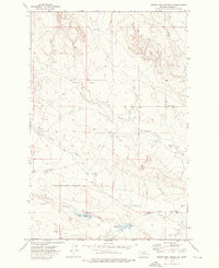
1972 Map of South Fork Reservoir
USGS Topo · Published 1976About this map
South Fork Reservoir and Clark Reservoir lie at the heart of this Prairie County landscape, providing essential water infrastructure in an area defined by the convergence of the North Fork Cherry Creek and South Fork Cherry Creek. The topography is shaped by the complex drainage system of Cherry Creek, featuring numerous springs such as Morris Spring and Sig Spring that suggest the importance of reliable water sources for local ranching and land management during the early 1970s.
Find a feature on this map
15 named features on this map. Tap any name to fly to it.
Don’t see what you’re looking for? This feature index may not catch every label — zoom into the map to look around manually.
Map Details
Editions of this 1972 South Fork Reservoir Map
This is the sole edition of this map. No revisions or reprints were ever made.
Other maps of this area

1953 · Miles City
USGS Topo · 1:250,000

1954 · Glendive
USGS Topo · 1:250,000

1957 · Miles City
USGS Topo · 1:250,000

1957 · Glendive
USGS Topo · 1:250,000

1958 · Miles City
USGS Topo · 1:250,000

1958 · Glendive
USGS Topo · 1:250,000

1965 · Little Sheep Mountain
USGS Topo · 1:24,000

1965 · Watkins SE
USGS Topo · 1:24,000

1965 · Morehouse Creek
USGS Topo · 1:24,000

1972 · Mc Clure Reservoir
USGS Topo · 1:24,000