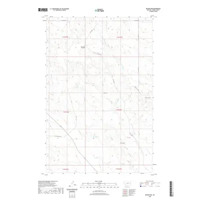
2020 Map of Becker Dam
USGS Topo · Published 2020About this map
The Big Sheep Mountains dominate this portion of Prairie County, where the landscape is defined by a network of drainage channels and high-plateau roads. Water management is central to the area's geography, evidenced by Becker Dam and Ban Reservoir Number 1, which capture runoff in an otherwise arid environment. The map shows a transition from the elevated peaks in the west toward the broken terrain of Timber Coulee and Smith Coulee to the southeast. Transport across these uplands relies on a series of historical thoroughfares including Cedar Creek Rd and the aptly named Bad Route Rd. These routes follow the natural topography, tracing the ridges and valleys carved by Cedar Cr and the E Fork Cedar Cr. This 2020 survey provides a clear view of the modern land divisions and water infrastructure in this remote Montana ranching corridor.
Find a feature on this map
19 named features on this map. Tap any name to fly to it.
Don’t see what you’re looking for? This feature index may not catch every label — zoom into the map to look around manually.
Map Details
Editions of this 2020 Becker Dam Map
This is the sole edition of this map. No revisions or reprints were ever made.
Other maps of this area

1953 · Miles City
USGS Topo · 1:250,000

1954 · Glendive
USGS Topo · 1:250,000

1957 · Miles City
USGS Topo · 1:250,000

1957 · Glendive
USGS Topo · 1:250,000

1958 · Miles City
USGS Topo · 1:250,000

1958 · Glendive
USGS Topo · 1:250,000

1972 · Papps Reservoir
USGS Topo · 1:24,000

1972 · Mc Cloud
USGS Topo · 1:24,000
1972 · South Fork Reservoir
USGS Topo · 1:24,000

1980 · Terry
USGS Topo · 1:100,000