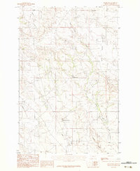
1983 Map of Becker Dam
USGS Topo · Published 1983About this map
Olanda sits in the northwest corner of this Eastern Montana landscape, representing a remote junction in a territory defined by complex drainage networks and ranchland infrastructure. The area is dominated by the seasonal and permanent flows of Cedar Creek and its major tributaries, including East Fork Cedar Creek and Brackett Creek. This 1983 provisional survey highlights the vital role of water management in the semi-arid Prairie County environment, clearly marking the Becker Dam and Ban Reservoir No 1. The terrain is characterized by dissected plateaus and coulees, such as Smith Coulee and Pasture Creek, which dictate the placement of unimproved roads and small-scale industry like the local Gravel Pit. The map documents a sparsely populated but carefully managed ranching landscape as it appeared in the late 1970s and early 1980s.
Find a feature on this map
9 named features on this map. Tap any name to fly to it.
Don’t see what you’re looking for? This feature index may not catch every label — zoom into the map to look around manually.
Map Details
Editions of this 1983 Becker Dam Map
This is the sole edition of this map. No revisions or reprints were ever made.
Other maps of this area

1953 · Miles City
USGS Topo · 1:250,000

1954 · Glendive
USGS Topo · 1:250,000

1957 · Miles City
USGS Topo · 1:250,000

1957 · Glendive
USGS Topo · 1:250,000

1958 · Miles City
USGS Topo · 1:250,000

1958 · Glendive
USGS Topo · 1:250,000

1972 · Papps Reservoir
USGS Topo · 1:24,000

1972 · Mc Cloud
USGS Topo · 1:24,000
1972 · South Fork Reservoir
USGS Topo · 1:24,000

1980 · Terry
USGS Topo · 1:100,000