
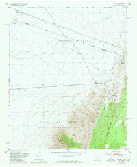
1952 Map of Becker
USGS Topo · Published 1953About this map
The high desert landscape of central New Mexico is defined here by the meeting of massive land grants and the infrastructure of the Atchison Topeka and Santa Fe railroad. The settlement of Becker sits near the northwestern corner, serving as a point along the rail line that cuts across the Casa Colorada Grant and the Belen Grant. These historic Spanish land grants, including the Sevilleta Grant to the south, dictate the regional boundaries and historical land use patterns.
Find a feature on this map
23 named features on this map. Tap any name to fly to it.
Don’t see what you’re looking for? This feature index may not catch every label — zoom into the map to look around manually.
Map Details
Editions of this 1952 Becker Map
2 editions found
Other maps of this area

1916 · La Joya
USGS Topo · 1:125,000

1917 · Estancia
USGS Topo · 1:125,000

1952 · Tome SE
USGS Topo · 1:24,000

1952 · Black Butte
USGS Topo · 1:24,000

1952 · Turn
USGS Topo · 1:24,000

1952 · Becker SW
USGS Topo · 1:24,000

1952 · Cerro Montoso
USGS Topo · 1:24,000

1954 · Torreon
USGS Topo · 1:62,500

1954 · Socorro
USGS Topo · 1:250,000

1958 · Socorro
USGS Topo · 1:250,000