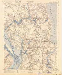
1907 Map of Beckford
USGS Topo · Published 1940About this map
The Chowan River and its intricate network of swamps and creek landings anchor this 1905–1906 survey of northeastern North Carolina. This landscape is defined by the transition from the dense interior of the Dismal Swamp to the timber and milling centers along Bennetts Creek. Significant inland water features like Merchants Millpond and Jones Pond appear alongside a busy steamboat route, highlighting the era's reliance on riverine transport for moving goods from landings such as Sandy Field Ldg and Taylor Whf.
Find a feature on this map
82 named features on this map. Tap any name to fly to it.
Don’t see what you’re looking for? This feature index may not catch every label — zoom into the map to look around manually.
Map Details
Editions of this 1907 Beckford Map
2 editions found
Other maps of this area

1904 · Edenton
USGS Topo · 1:62,500

1906 · Hertford
USGS Topo · 1:62,500

1906 · Beckford
USGS Topo · 1:48,000

1907 · Beckford
USGS Topo · 1:62,500

1908 · Winton
USGS Topo · 1:62,500

1919 · Suffolk
USGS Topo · 1:62,500

1920 · Holland
USGS Topo · 1:62,500

1940 · Hertford
USGS Topo · 1:62,500

1940 · Beckford
USGS Topo · 1:62,500

1940 · Lake Drummond
USGS Topo · 1:62,500