
1907 Map of Beckford
USGS Topo · Published 1907About this map
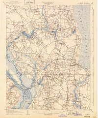
Chowan River and the sprawling Dismal Swamp define the eastern and western boundaries of this landscape at the onset of the twentieth century. The interior is a complex network of wetlands and agricultural settlements, where life centered on the local millponds and river landings. Features like Merchants Millpond and Hunters Millpond provided essential industry, while steam navigation facilitated trade along the river at Mt Pleasant Whf and Taylor Whf.
Find a feature on this map
108 named features on this map. Tap any name to fly to it.
Don’t see what you’re looking for? This feature index may not catch every label — zoom into the map to look around manually.
Map Details
Editions of this 1907 Beckford Map
2 editions found
Other maps of this area

1904 · Edenton
USGS Topo · 1:62,500

1906 · Hertford
USGS Topo · 1:62,500

1906 · Beckford
USGS Topo · 1:48,000

1908 · Winton
USGS Topo · 1:62,500

1919 · Suffolk
USGS Topo · 1:62,500

1920 · Holland
USGS Topo · 1:62,500

1940 · Hertford
USGS Topo · 1:62,500

1940 · Beckford
USGS Topo · 1:62,500

1940 · Lake Drummond
USGS Topo · 1:62,500

1940 · South Mills
USGS Topo · 1:62,500