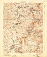
1932 Map of Beckley
USGS Topo · Published 1932About this map
The New River carves a deep, winding canyon through the heart of the central West Virginia coalfields, creating a landscape where topography dictated the path of industry and settlement. The Chesapeake and Ohio railway hugs the riverbanks, connecting coal-loading points like Thurmond and Sewell to the outside world. This survey shows the dense cluster of industrial settlements that followed the seams, including Glen Jean, Oak Hill, and Minden, many of which were founded as company towns.
Find a feature on this map
140 named features on this map. Tap any name to fly to it.
Don’t see what you’re looking for? This feature index may not catch every label — zoom into the map to look around manually.
Map Details
Editions of this 1932 Beckley Map
2 editions found
Other maps of this area

1887 · Hinton
USGS Topo · 1:125,000

1889 · Nicholas
USGS Topo · 1:125,000

1891 · Nicholas
USGS Topo · 1:125,000

1891 · Raleigh
USGS Topo · 1:125,000

1892 · Hinton
USGS Topo · 1:125,000

1897 · Kanawha Falls
USGS Topo · 1:125,000

1897 · Raleigh
USGS Topo · 1:125,000

1900 · Kanawha Falls
USGS Topo · 1:125,000

1901 · Nicholas
USGS Topo · 1:125,000

1901 · Kanawha Falls
USGS Topo · 1:125,000