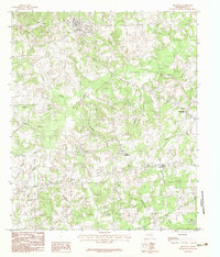
1983 Map of Beckville
USGS Topo · Published 1983About this map
Beckville serves as the primary hub in this portion of Panola County, where the local landscape is defined by an intricate network of slow-moving waterways and bottomlands. Several bayous, including Irons Bayou and Buckner Bayou, snake through the terrain, feeding into local landmarks like Shelby Lake and Dixie Lake. The map reveals a rural economy shaped by natural resources, evidenced by the scattered Gravel Pit operations and the presence of small communities like Riderville, Delray, and Holland Quarters. A significant piece of transportation history is preserved here in the form of an Old Railroad Grade that cuts through the topography, marking a defunct path of commerce. Local genealogy interests are supported by multiple marked Cem locations, indicating family burial grounds or community churchyards that have served these settlements for generations.
Find a feature on this map
28 named features on this map. Tap any name to fly to it.
Don’t see what you’re looking for? This feature index may not catch every label — zoom into the map to look around manually.
Map Details
Editions of this 1983 Beckville Map
2 editions found
Other maps of this area

1956 · Tyler
USGS Topo · 1:250,000

1958 · Darco
USGS Topo · 1:62,500

1958 · Carthage
USGS Topo · 1:62,500

1958 · Tatum
USGS Topo · 1:62,500

1960 · Minden
USGS Topo · 1:62,500

1983 · Grand Bluff
USGS Topo · 1:24,000

1983 · Tatum
USGS Topo · 1:24,000

1983 · Harris Chapel
USGS Topo · 1:24,000

1983 · Long Branch
USGS Topo · 1:24,000

1983 · Fair Play
USGS Topo · 1:24,000