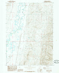
1985 Map of Beckwith
USGS Topo · Published 1985About this map
The Bear River winds through this high valley in Lincoln County, creating a complex network of oxbows and wetlands that defined the local geography during the 1980s. Near the western edge, the small settlement of Beckwith is situated along the transport corridor, while Pixley sits further north, anchoring a landscape shaped by early water management systems. A series of man-made waterways, including the Mau Canal, Covey Canal, and Pixley Ditch, illustrate the importance of irrigation to this arid mountain region. To the east, the terrain rises sharply into the prominent elevations of Stoffer Ridge and Boulder Ridge. Notable landmarks like The Big Knob and the road identified as Mc Farland provide specific points of interest for those tracing the history of land use and transit in the Bear River Valley.
Find a feature on this map
22 named features on this map. Tap any name to fly to it.
Don’t see what you’re looking for? This feature index may not catch every label — zoom into the map to look around manually.
Map Details
Editions of this 1985 Beckwith Map
This is the sole edition of this map. No revisions or reprints were ever made.
Other maps of this area

1909 · Montpelier
USGS Topo · 1:125,000

1911 · Montpelier
USGS Topo · 1:125,000

1912 · Randolph
USGS Topo · 1:125,000

1936 · Cokeville
USGS Topo · 1:96,000

1942 · Cokeville
USGS Topo · 1:125,000

1954 · Sage
USGS Topo · 1:62,500

1954 · Ogden
USGS Topo · 1:250,000

1955 · Preston
USGS Topo · 1:250,000

1958 · Ogden
USGS Topo · 1:250,000

1958 · Preston
USGS Topo · 1:250,000