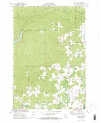
1972 Map of Becky Creek
USGS Topo · Published 1975About this map
The timber-rich terrain of northwestern Wisconsin is documented here in the early 1970s, showcasing the transition from industrial logging roots to modern land management. Evidence of the region's earlier commercial era is visible through the Old Railroad Grade that winds through the northern sections, cutting across the paths of Big Weirgor Creek and Spring Creek. The topography is defined by the sharp division between the townships of Murry and Atlanta, with the small settlement of Adams serving as a primary human landmark on Meadow Dam Road.
Find a feature on this map
16 named features on this map. Tap any name to fly to it.
Don’t see what you’re looking for? This feature index may not catch every label — zoom into the map to look around manually.
Map Details
Editions of this 1972 Becky Creek Map
2 editions found
Other maps of this area

1944 · Exeland
USGS Topo · 1:48,000

1945 · Meteor
USGS Topo · 1:48,000

1947 · Exeland
USGS Topo · 1:48,000

1948 · Weyerhauser
USGS Topo · 1:48,000

1948 · Ladysmith
USGS Topo · 1:48,000

1949 · Meteor
USGS Topo · 1:48,000

1950 · Weyerhauser
USGS Topo · 1:48,000

1950 · Ladysmith
USGS Topo · 1:48,000

1953 · Rice Lake
USGS Topo · 1:250,000

1959 · Rice Lake
USGS Topo · 1:250,000