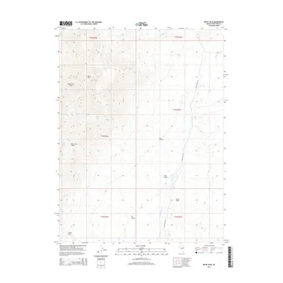
2014 Map of Becky Peak
USGS Topo · Published 2014About this map
Becky Peak and the high ridges of the Schell Creek Range dominate this interior Nevada landscape, where water sources are the primary indicators of human and animal activity. A network of vital watering points defines the mountain terrain, including Camp Spring, Gravel Spring, Mustang Spring, and the curiously named Dolans Trap Spring. These locations, often the only reliable water for miles, historically supported ranching and transit through the Great Basin. To the east, the land descends into the wide expanse of Spring Valley, drained by Spring Valley Cr and north-flowing Sampson Cr. The map reveals the intricate drainage patterns of the high desert, from the narrow confines of Dolans Trap Canyon and Box Canyon to the broader flats. Transport is represented by the north-south transit of Spring Valley Rd, which skirts the base of the mountains as they transition into the valley floor.
Find a feature on this map
26 named features on this map. Tap any name to fly to it.
Don’t see what you’re looking for? This feature index may not catch every label — zoom into the map to look around manually.
Map Details
Editions of this 2014 Becky Peak Map
This is the sole edition of this map. No revisions or reprints were ever made.
Other maps of this area

1955 · Elko
USGS Topo · 1:250,000

1956 · Ely
USGS Topo · 1:250,000

1958 · Elko
USGS Topo · 1:250,000

1959 · Ely
USGS Topo · 1:250,000

1962 · Elko
USGS Topo · 1:250,000

1963 · Ely
USGS Topo · 1:250,000

1965 · Elko
USGS Topo · 1:250,000

1982 · Chin Creek Spring
USGS Topo · 1:24,000

1982 · Cherry Spring
USGS Topo · 1:24,000
1982 · Goshute Lake South
USGS Topo · 1:24,000