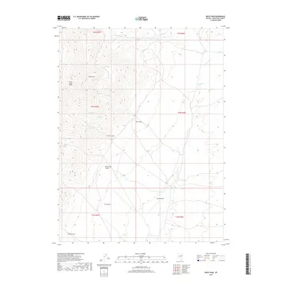
2018 Map of Becky Peak
USGS Topo · Published 2018About this map
Becky Peak stands as the prominent high point within the Schell Creek Range, overlooking a landscape defined by seasonal drainages and essential water sources. This high-altitude Nevada terrain is characterized by numerous named springs that historically served as critical waypoints for travel and ranching, including Gravel Spring, Mustang Spring, and Dolans Trap Spring. The map documents a rugged drainage network where Box Canyon and Horse Canyon carve through the mountains toward the broad expanse of Spring Valley to the east. The transition from the steep slopes of the Schell Creek Range to the valley floor is traced by several watercourses such as Spring Valley Cr and Middle Cr. This documentation of water access points and topographic contours provides a detailed record of the environmental constraints that have shaped land use in this part of White Pine County.
Find a feature on this map
25 named features on this map. Tap any name to fly to it.
Don’t see what you’re looking for? This feature index may not catch every label — zoom into the map to look around manually.
Map Details
Editions of this 2018 Becky Peak Map
This is the sole edition of this map. No revisions or reprints were ever made.
Other maps of this area

1955 · Elko
USGS Topo · 1:250,000

1956 · Ely
USGS Topo · 1:250,000

1958 · Elko
USGS Topo · 1:250,000

1959 · Ely
USGS Topo · 1:250,000

1962 · Elko
USGS Topo · 1:250,000

1963 · Ely
USGS Topo · 1:250,000

1965 · Elko
USGS Topo · 1:250,000

1982 · Chin Creek Spring
USGS Topo · 1:24,000

1982 · Cherry Spring
USGS Topo · 1:24,000
1982 · Goshute Lake South
USGS Topo · 1:24,000