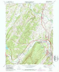
1971 Map of Bedford
USGS Topo · Published 1987About this map
Raystown Branch Juniata River and Dunning Creek converge near the growing borough of Bedford, a landscape where mid-century transportation infrastructure meets deep-rooted Pennsylvania settlements. The topography is defined by the massive ridges of Wills Mountain and Chestnut Ridge, which channel development into valleys containing villages like Wolfsburg, Cessna, and Napier. This 1970s record highlights the evolution of regional travel, documenting the Pennsylvania Turnpike and its Interchange 11 alongside the remnants of a dismantled railroad network. Local landmarks of interest to genealogists include St Pauls Cem, St Lukes Ch, and the Bedford Memorial Gardens. To the west, the man-made Shawnee Lake within Shawnee State Park represents a significant recreational shift in the valley, contrasting with the industrial presence of a Quarry and various Gravel Pits found near Belden.
Find a feature on this map
48 named features on this map. Tap any name to fly to it.
Don’t see what you’re looking for? This feature index may not catch every label — zoom into the map to look around manually.
Map Details
Editions of this 1971 Bedford Map
3 editions found
Other maps of this area

1900 · Everett
USGS Topo · 1:62,500

1902 · Everett
USGS Topo · 1:62,500

1908 · Bedford
USGS Topo · 1:62,500

1910 · Bedford
USGS Topo · 1:62,500

1927 · Clearville
USGS Topo · 1:48,000

1927 · Hyndman
USGS Topo · 1:62,500

1931 · Clearville
USGS Topo · 1:62,500

1931 · Hyndman
USGS Topo · 1:62,500

1944 · Hyndman
USGS Topo · 1:62,500

1944 · Clearville
USGS Topo · 1:62,500