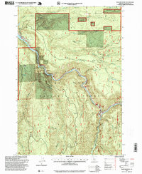
1997 Map of Bedford Point
USGS Topo · Published 1999About this map
The North Fork Clackamas River carves through this portion of the Mt Hood National Forest, revealing a landscape defined by forestry management and industrial resource extraction in the late 20th century. At Memaloose, the river is flanked by infrastructure such as the Oregon City Water Patrol Station and a nearby Cable Crossing. The prevalence of sites like the Lazy Bend Quarry, Bee Creek Quarry, and the Carter Bridge Gravel Pit suggests an era of active road maintenance and construction within the federal timberlands.
Find a feature on this map
32 named features on this map. Tap any name to fly to it.
Don’t see what you’re looking for? This feature index may not catch every label — zoom into the map to look around manually.
Map Details
Editions of this 1997 Bedford Point Map
This is the sole edition of this map. No revisions or reprints were ever made.
Other maps of this area

1911 · Boring
USGS Topo · 1:48,000

1914 · Boring
USGS Topo · 1:62,500

1916 · Estacada
USGS Topo · 1:125,000

1940 · Boring
USGS Topo · 1:62,500

1948 · Vancouver
USGS Topo · 1:250,000

1950 · Vancouver
USGS Topo · 1:250,000

1950 · Vancouver
USGS Topo · 1:250,000
1954 · Estacada
USGS Topo · 1:24,000

1955 · Colton
USGS Topo · 1:62,500

1955 · Cherryville
USGS Topo · 1:62,500