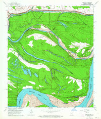
1963 Map of Bedford
USGS Topo · Published 1964About this map
The Mississippi River creates a complex landscape of shifting borders and braided waterways in this 1963 survey of the borderlands between Louisiana and Mississippi. The map reveals the intricate meander patterns of the river, where the Louisiana Mississippi state line and various parish boundaries follow old channels that have long since been bypassed by the main current. This creates unique geographic anomalies like Palmyra Island and Diamond Island, where land ownership is dictated by the river's historic path. Evidence of local aviation and rural infrastructure is scattered across these river bends, including the Parker Landing Strip and Diamond Point Landing Strip. Settlement is concentrated near the river's edge at Bedford and King, while inland features like Crystal Springs Cem and Hodges Cem provide critical points of interest for those researching the genealogy of Madison Parish and the surrounding river bottomlands.
Find a feature on this map
37 named features on this map. Tap any name to fly to it.
Don’t see what you’re looking for? This feature index may not catch every label — zoom into the map to look around manually.
Map Details
Editions of this 1963 Bedford Map
2 editions found
Other maps of this area

1909 · Mound
USGS Topo · 1:24,000

1910 · Mound
USGS Topo · 1:31,680

1918 · Vicksburg
USGS Topo · 1:62,500

1939 · Talla Bena
USGS Topo · 1:62,500

1939 · Yokena
USGS Topo · 1:62,500

1941 · Vicksburg
USGS Topo · 1:62,500

1955 · Jackson
USGS Topo · 1:250,000

1961 · Jackson
USGS Topo · 1:250,000

1962 · Jackson
USGS Topo · 1:250,000

1962 · Vicksburg West
USGS Topo · 1:24,000