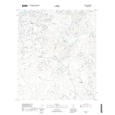
2019 Map of Bee Cave
USGS Topo · Published 2019About this map
Bee Cave sits at the heart of this Travis County survey, where the expanding suburbs of west Austin meet the complex drainages of the Texas Hill Country. The landscape is defined by the winding course of the Colorado River, which forms both Lake Travis in the northwest and Lake Austin further downstream. The map documents the dense residential development around Lakeway and The Hills, contrasted against the significant relief of Chalk Knob, Maul Hill, and Dittmar Hill. Genealogists will find several burial sites including White Rock Cem and Roberts Cem, while hydrologic features like Santa Monica Springs and Thomas Springs point to the area's natural water sources. The transition from rural hilly terrain to modern commerce is evident in the corridors surrounding the Shops at the Galleria Pkwy, illustrating the rapid suburban growth occurring during this era.
Find a feature on this map
243 named features on this map. Tap any name to fly to it.
Don’t see what you’re looking for? This feature index may not catch every label — zoom into the map to look around manually.
Map Details
Editions of this 2019 Bee Cave Map
This is the sole edition of this map. No revisions or reprints were ever made.
Other maps of this area

1887 · Blanco
USGS Topo · 1:125,000

1894 · Blanco
USGS Topo · 1:125,000

1896 · Austin
USGS Topo · 1:125,000

1897 · Austin
USGS Topo · 1:125,000

1910 · Austin
USGS Topo · 1:125,000

1930 · Austin-2
USGS Topo · 1:48,000

1930 · Blanco-1
USGS Topo · 1:48,000

1932 · Mt. Bonnell
USGS Topo · 1:62,500

1954 · Austin West
USGS Topo · 1:24,000

1954 · Llano
USGS Topo · 1:250,000