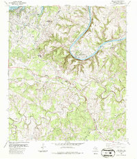
1986 Map of Bee Cave
USGS Topo · Published 1986About this map
Bee Cave Road and the winding course of the Colorado River anchor this mid-1980s topographic study of the Texas Hill Country west of Austin. The landscape is characterized by the transition from rural ranching roots to residential growth, visible in the contrast between the sprawling Shield Ranch and the developing community of Lakeway. The topography is defined by deep incisions like Hickson Hollow and Harrison Hollow that drain toward Lake Travis and Lake Austin. Local history is preserved in several small burial grounds, including White Rock Cem and Bee Cave Cem, while the Trading Post near the junction of Barton Creek and Little Barton Creek marks a traditional point of commerce. Public spaces like Commons Ford Metropolitan Park and Selma Hughes Park line the riverbanks, showcasing the area's mid-century shift toward recreation and conservation.
Find a feature on this map
50 named features on this map. Tap any name to fly to it.
Don’t see what you’re looking for? This feature index may not catch every label — zoom into the map to look around manually.
Map Details
Editions of this 1986 Bee Cave Map
This is the sole edition of this map. No revisions or reprints were ever made.
Other maps of this area

1887 · Blanco
USGS Topo · 1:125,000

1894 · Blanco
USGS Topo · 1:125,000

1896 · Austin
USGS Topo · 1:125,000

1897 · Austin
USGS Topo · 1:125,000

1910 · Austin
USGS Topo · 1:125,000

1930 · Austin-2
USGS Topo · 1:48,000

1930 · Blanco-1
USGS Topo · 1:48,000

1932 · Mt. Bonnell
USGS Topo · 1:62,500

1954 · Austin West
USGS Topo · 1:24,000

1954 · Llano
USGS Topo · 1:250,000