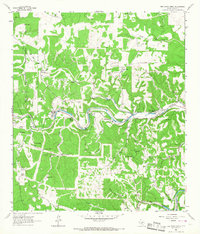
1964 Map of Bee Caves Creek
USGS Topo · Published 1967About this map
The North Fork Guadalupe River and South Fork Guadalupe River dominate this 1964 terrain of Kerr County, Texas. This landscape is defined by its abundant natural water sources and large-scale ranching operations, including the Kerr Wildlife Management Area and historic spreads like Patio Ranch, Wagon Wheel Ranch, and the Mo Ranch. The abundance of named springs, such as Bee Caves Spring, Muskhog Spring, and Lange Spring, suggests a high reliance on groundwater for the local cattle and wildlife management industries. This survey captures a specific network of windmills—such as the Ringtail Windmill, Four Corners Windmill, and Jarman Windmill—which serve as critical landmarks for genealogists and local historians tracing the development of water infrastructure across the limestone hills and creek beds.
Find a feature on this map
33 named features on this map. Tap any name to fly to it.
Don’t see what you’re looking for? This feature index may not catch every label — zoom into the map to look around manually.
Map Details
Editions of this 1964 Bee Caves Creek Map
This is the sole edition of this map. No revisions or reprints were ever made.
Other maps of this area

1894 · Kerrville
USGS Topo · 1:125,000

1954 · Llano
USGS Topo · 1:250,000

1954 · San Antonio
USGS Topo · 1:250,000

1955 · Llano
USGS Topo · 1:250,000

1956 · Tuff
USGS Topo · 1:62,500

1956 · Llano
USGS Topo · 1:250,000

1957 · San Antonio
USGS Topo · 1:250,000

1964 · Boneyard Draw
USGS Topo · 1:24,000

1964 · Well Hollow
USGS Topo · 1:24,000

1964 · Diamond S Ranch
USGS Topo · 1:24,000