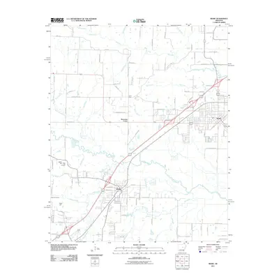
2011 Map of Beebe
USGS Topo · Published 2011About this map
Beebe and Ward serve as the primary hubs in this White County landscape, where the flatlands are defined by an intricate network of waterways including Cypress Bayou, Bull Creek, and Gum Creek. The map documents a blend of established residential grids and smaller rural settlements such as Stony Point, Barrentine Corner, and Apple Hill. Genealogists will find particular value in the placement of the Apple Hill Cemetery and Rock Hill Cemetery, which are preserved alongside family-named landmarks like Stoney Point Church Rd and Marvin Fisher Rd. The presence of Railroad St in the heart of Beebe underscores the historical importance of the rail corridor in shaping the town's development. Small-scale drainage features like Red Cut Slough and Sims Branch highlight the area's low-lying character, while various spur roads like Hwy 321 Spur indicate modern connectivity between these early Arkansas communities.
Find a feature on this map
113 named features on this map. Tap any name to fly to it.
Don’t see what you’re looking for? This feature index may not catch every label — zoom into the map to look around manually.
Map Details
Editions of this 2011 Beebe Map
This is the sole edition of this map. No revisions or reprints were ever made.
Other maps of this area

1891 · Little Rock
USGS Topo · 1:125,000

1893 · Little Rock
USGS Topo · 1:125,000

1940 · Lonoke
USGS Topo · 1:62,500

1941 · Cabot
USGS Topo · 1:31,680

1948 · Helena
USGS Topo · 1:250,000

1949 · Lonoke
USGS Topo · 1:62,500

1950 · Helena
USGS Topo · 1:250,000

1950 · Lonoke
USGS Topo · 1:62,500

1953 · Memphis
USGS Topo · 1:250,000
1954 · Cabot
USGS Topo · 1:24,000