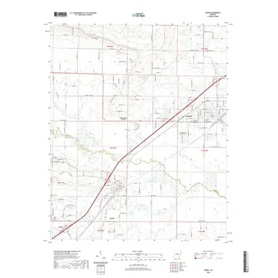
2020 Map of Beebe
USGS Topo · Published 2020About this map
Beebe serves as a central hub in this modern era survey, where the Union Pacific railroad and major highways converge near the Arkansas State University Beebe campus. The landscape transitions from the developed streets of Ward and Austin to the more rural, undulating terrain of the Cadron Ridge and Haymes Hill to the northwest. This area is defined by its numerous small waterways, including the winding Cypress Bayou and Bull Creek, which drain the lowlands between local ridges. Genealogists and local historians can find several established burial sites, such as Apple Hill Cem and Rock Hill Cem, alongside smaller residential developments like Lynnwood Acres and Barrentine Corner. The map clearly delineates the White Co Lonoke Co boundary, illustrating how these communities span the border between the two counties.
Find a feature on this map
162 named features on this map. Tap any name to fly to it.
Don’t see what you’re looking for? This feature index may not catch every label — zoom into the map to look around manually.
Map Details
Editions of this 2020 Beebe Map
This is the sole edition of this map. No revisions or reprints were ever made.
Other maps of this area

1891 · Little Rock
USGS Topo · 1:125,000

1893 · Little Rock
USGS Topo · 1:125,000

1940 · Lonoke
USGS Topo · 1:62,500

1941 · Cabot
USGS Topo · 1:31,680

1948 · Helena
USGS Topo · 1:250,000

1949 · Lonoke
USGS Topo · 1:62,500

1950 · Helena
USGS Topo · 1:250,000

1950 · Lonoke
USGS Topo · 1:62,500

1953 · Memphis
USGS Topo · 1:250,000
1954 · Cabot
USGS Topo · 1:24,000