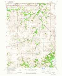
1965 Map of Beech
USGS Topo · Published 1966About this map
Beech sits along the northern edge of this Marion County survey, serving as a focal point along the Chicago Rock Island And Pacific railroad. The landscape is defined by the drainage basins of Coal Creek and Coon Creek, which carve through the townships of Union, Pleasant Grove, Belmont, and Franklin. The map captures the agricultural and religious infrastructure of the mid-1960s, documenting local landmarks like Motor Ch and Highland Cem near the small settlement of Motor. To the south, the village of Caloma stands near a modern Pipeline corridor. A significant geographic feature is the Lake Red Rock inundation area along White Breast Creek in the southeast corner, indicating the shifting hydrologic landscape as the Des Moines River valley was managed for flood control.
Find a feature on this map
18 named features on this map. Tap any name to fly to it.
Don’t see what you’re looking for? This feature index may not catch every label — zoom into the map to look around manually.
Map Details
Editions of this 1965 Beech Map
This is the sole edition of this map. No revisions or reprints were ever made.
Other maps of this area

1909 · Knoxville
USGS Topo · 1:62,500

1910 · Milo
USGS Topo · 1:62,500

1912 · Knoxville
USGS Topo · 1:62,500

1918 · Chariton
USGS Topo · 1:62,500

1924 · Melcher
USGS Topo · 1:62,500

1954 · Des Moines
USGS Topo · 1:250,000

1956 · Des Moines
USGS Topo · 1:250,000

1957 · Des Moines
USGS Topo · 1:250,000

1965 · Pleasantville
USGS Topo · 1:24,000

1965 · Milo
USGS Topo · 1:24,000