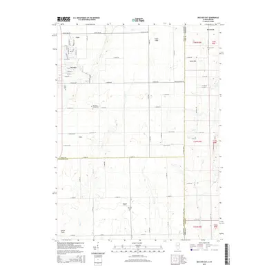
2015 Map of Beecher East
USGS Topo · Published 2015About this map
The village of Beecher sits at the western edge of this landscape, where the agricultural plains of Will County meet the Indiana state line. This borderland region is defined by a grid of rural roads and scattered historical settlements like Klaasville, Brunswick, and Eagle Lake. The drainage patterns of Trim Cr and Pike Cr wind through the township sections, influencing the placement of early homesteads and community centers. Significant for genealogists, the map identifies several distinct burial grounds and parish sites, including Saint Johns United Church of Christ Cem and the Saint Paul Lutheran Cem. The presence of Mussman Airport and the transition across the Will Co / Kankakee Co line illustrates the modern infrastructure layered over a deep-rooted farming community that has long served as a gateway between Illinois and Indiana.
Find a feature on this map
69 named features on this map. Tap any name to fly to it.
Don’t see what you’re looking for? This feature index may not catch every label — zoom into the map to look around manually.
Map Details
Editions of this 2015 Beecher East Map
This is the sole edition of this map. No revisions or reprints were ever made.
Other maps of this area

1922 · Momence
USGS Topo · 1:62,500

1924 · Momence
USGS Topo · 1:62,500

1929 · Dyer
USGS Topo · 1:24,000

1930 · Dyer
USGS Topo · 1:24,000

1930 · Steger
USGS Topo · 1:24,000

1949 · Crete
USGS Topo · 1:62,500

1953 · St. John
USGS Topo · 1:24,000
1953 · Steger
USGS Topo · 1:24,000

1953 · Beecher West
USGS Topo · 1:24,000

1953 · Beecher East
USGS Topo · 1:24,000