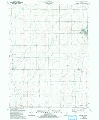
1990 Map of Beecher West
USGS Topo · Published 1991About this map
The prairie landscape at the boundary of Will and Kankakee counties reveals a strictly organized agricultural grid defined by an extensive network of drainage sloughs and creeks. Small rural centers and community hubs like Beecher and Sollitt anchor the eastern side of the map, while Whitaker sits at the southwestern edge. The region's social history is marked by several country institutions, including St Pauls Ch, Zion Ch, and the Zion Sch. A transition in land use is evident in the presence of private aviation facilities like the Norman Landing Strip and Von Alven Landing Strip, alongside significant infrastructure projects represented by multiple pipelines cutting diagonally across the township lines of Washington, Sumner, and Yellowhead. Natural watercourses like Black Walnut Creek and Trim Creek weave through the rectangular sections, essential to the drainage of this fertile farming belt in the final decade of the century.
Find a feature on this map
36 named features on this map. Tap any name to fly to it.
Don’t see what you’re looking for? This feature index may not catch every label — zoom into the map to look around manually.
Map Details
Editions of this 1990 Beecher West Map
This is the sole edition of this map. No revisions or reprints were ever made.
Other maps of this area

1922 · Momence
USGS Topo · 1:62,500

1922 · Kankakee
USGS Topo · 1:62,500

1924 · Momence
USGS Topo · 1:62,500

1924 · Kankakee
USGS Topo · 1:62,500

1929 · Dyer
USGS Topo · 1:24,000

1930 · Dyer
USGS Topo · 1:24,000

1930 · Frankfort
USGS Topo · 1:24,000

1930 · Steger
USGS Topo · 1:24,000

1949 · Peotone
USGS Topo · 1:62,500

1949 · Crete
USGS Topo · 1:62,500