
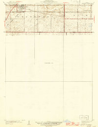
1930 Map of Frankfort
USGS Topo · Published 1930About this map
The village of Frankfort is the central hub of this 1927 survey, showing its early development along the Elgin, Joliet, and Eastern railroad corridor. The surrounding landscape is defined by the Old Indian Boundary, which slices diagonally across the terrain, reflecting the early surveying history of northern Illinois. Beyond the town grid, the map records the rural educational and religious infrastructure of the era, including the Washington Royal School, Rahm School, and Pleasant Hill Cem. The southern edge of the sheet follows the Steger Road along the border between Frankfort and Rich townships. This preliminary edition is notable for its use of aerial photography compiled by the Army Air Corps, providing a transition between traditional field surveying and modern photogrammetry at a time when much of the southern portion of the quadrangle remained an unsurveyed area.
Find a feature on this map
18 named features on this map. Tap any name to fly to it.
Don’t see what you’re looking for? This feature index may not catch every label — zoom into the map to look around manually.
Map Details
Editions of this 1930 Frankfort Map
2 editions found
Other maps of this area

1890 · Des Plaines
USGS Topo · 1:62,500

1892 · Calumet
USGS Topo · 1:62,500

1893 · Calumet
USGS Topo · 1:62,500

1894 · Des Plaines
USGS Topo · 1:62,500

1900 · Des Plaines
USGS Topo · 1:62,500

1900 · Calumet
USGS Topo · 1:62,500

1901 · Calumet
USGS Topo · 1:62,500

1901 · Des Plaines
USGS Topo · 1:62,500

1929 · Tinley Park
USGS Topo · 1:24,000

1929 · Brisbane
USGS Topo · 1:24,000