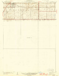
1930 Map of Frankfort
USGS Topo · Published 1946About this map
The village of Frankfort serves as the focal point of this northern Illinois landscape, positioned where the Michigan Central and Elgin Joliet and Eastern Trans Line railroads intersect. This 1940s-era revision of earlier surveys reveals a landscape deeply influenced by historical passage and transit. The diagonal line of the Old Indian Boundary cuts across the township of Frankfort, while the ancient east-west route of the Sauk Trail traverses both Will and Cook counties.
Find a feature on this map
15 named features on this map. Tap any name to fly to it.
Don’t see what you’re looking for? This feature index may not catch every label — zoom into the map to look around manually.
Map Details
Editions of this 1930 Frankfort Map
2 editions found

Other maps of this area

1890 · Des Plaines
USGS Topo · 1:62,500

1892 · Calumet
USGS Topo · 1:62,500

1893 · Calumet
USGS Topo · 1:62,500

1894 · Des Plaines
USGS Topo · 1:62,500

1900 · Des Plaines
USGS Topo · 1:62,500

1900 · Calumet
USGS Topo · 1:62,500

1901 · Calumet
USGS Topo · 1:62,500

1901 · Des Plaines
USGS Topo · 1:62,500

1929 · Tinley Park
USGS Topo · 1:24,000

1929 · Brisbane
USGS Topo · 1:24,000