
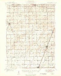
1949 Map of Peotone
USGS Topo · Published 1949About this map
Agricultural lands and emerging railroad towns define this post-war landscape across southern Will County and northern Kankakee County. The Peotone village core is shown at a critical juncture, serving as a hub for the Illinois Central RR and Chicago Milwaukee St Paul and Pacific RR. The area’s rural character is evidenced by the high density of country schools, such as Fivemile Grove Sch and Wallingford Sch, which anchored farming communities before the mid-century trend toward school consolidation. To the northwest, Manhattan and Frankfort appear as distinct rail-served settlements, while smaller points like Wilton Center and Andres provide insight into the historic spacing of local commerce. Numerous watercourses, including Forked Creek and Jackson Creek, dictate the township's drainage patterns, supporting the intensive farming that defines the region.
Find a feature on this map
80 named features on this map. Tap any name to fly to it.
Don’t see what you’re looking for? This feature index may not catch every label — zoom into the map to look around manually.
Map Details
Editions of this 1949 Peotone Map
2 editions found
Other maps of this area

1890 · Des Plaines
USGS Topo · 1:62,500

1892 · Joliet
USGS Topo · 1:62,500

1892 · Calumet
USGS Topo · 1:62,500

1892 · Wilmington
USGS Topo · 1:62,500

1893 · Calumet
USGS Topo · 1:62,500

1894 · Des Plaines
USGS Topo · 1:62,500

1900 · Des Plaines
USGS Topo · 1:62,500

1900 · Calumet
USGS Topo · 1:62,500

1901 · Calumet
USGS Topo · 1:62,500

1901 · Des Plaines
USGS Topo · 1:62,500