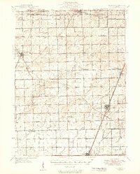
1949 Map of Peotone
USGS Topo · Published 1949About this map
The Illinois Central and Wabash RR corridors define the development of eastern Will County in the mid-1940s, connecting agricultural hubs like Peotone and Manhattan to the broader regional market. This landscape is remarkably dense with rural education and religious landmarks, featuring a grid of family-named schoolhouses such as Pfundstein Sch, Hansen Sch, and Hasenjager Sch that served the farming community before the era of school consolidation.
Find a feature on this map
86 named features on this map. Tap any name to fly to it.
Don’t see what you’re looking for? This feature index may not catch every label — zoom into the map to look around manually.
Map Details
Editions of this 1949 Peotone Map
2 editions found

Other maps of this area

1890 · Des Plaines
USGS Topo · 1:62,500

1892 · Joliet
USGS Topo · 1:62,500

1892 · Calumet
USGS Topo · 1:62,500

1892 · Wilmington
USGS Topo · 1:62,500

1893 · Calumet
USGS Topo · 1:62,500

1894 · Des Plaines
USGS Topo · 1:62,500

1900 · Des Plaines
USGS Topo · 1:62,500

1900 · Calumet
USGS Topo · 1:62,500

1901 · Calumet
USGS Topo · 1:62,500

1901 · Des Plaines
USGS Topo · 1:62,500