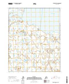
2017 Map of Beechey Point A-2 NE
USGS Topo · Published 2017About this map
Beaufort Sea waters meet the low-lying coastal plains of Alaska's North Slope in this 2017 study. The landscape is defined by an intricate network of wetlands, thaw lakes, and tidal flats where the Kadleroshilik River winds toward its mouth at the coast. The geography is dominated by the transition from terrestrial tundra to the marine environment of Foggy Island Bay, a sheltered area protected by the small landform of Foggy Island. This region illustrates the specialized hydrologic patterns of the Arctic, characterized by numerous small, unnamed ponds and the shifting gravel bars of braided river channels as they approach the sea. The map provides a precise look at the township and range boundaries, including t10n r17e and t9n r18e, which organize this largely uninhabited territory.
Find a feature on this map
8 named features on this map. Tap any name to fly to it.
Don’t see what you’re looking for? This feature index may not catch every label — zoom into the map to look around manually.
Map Details
Editions of this 2017 Beechey Point A-2 NE Map
This is the sole edition of this map. No revisions or reprints were ever made.
Other maps of this area

1951 · Beechey Point
USGS Topo · 1:250,000

1955 · Beechey Point
USGS Topo · 1:250,000

1955 · Beechey Point B-2
USGS Topo · 1:63,360

1955 · Beechey Point B-1
USGS Topo · 1:63,360

1955 · Beechey Point A-1
USGS Topo · 1:63,360

1955 · Beechey Point A-2
USGS Topo · 1:63,360

1960 · Beechey Point
USGS Topo · 1:250,000
1962 · Beechey Point A-1
USGS Topo · 1:50,000

1962 · Beechey Point B-2
USGS Topo · 1:50,000
1962 · Beechey Point B-1
USGS Topo · 1:50,000