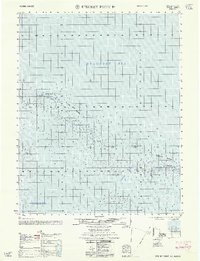
1962 Map of Beechey Point B-1
USGS Topo · Published 1962About this map
The Beaufort Sea coast of Alaska's North Slope is documented here as it appeared in the mid-1950s, focusing on the barrier island chains that buffer the mainland from the Arctic. This hydrographic study, compiled by the Army Map Service using data from the Usc&GS, provides a specialized look at the shoals and depths surrounding the McClure Islands and the Stockton Islands. Individual landforms like Narwhal Island, Jeanette Island, and Pole Island are mapped alongside sounding measurements in fathoms, revealing the complex underwater topography of Foggy Island Bay. The map also defines the Newport Entrance, a critical passage for vessels navigating these northern waters. As a record of the shoreline before the major industrial shifts on the North Slope, it preserves the exact position of these migratory gravel islands and the navigable channels between them.
Find a feature on this map
9 named features on this map. Tap any name to fly to it.
Don’t see what you’re looking for? This feature index may not catch every label — zoom into the map to look around manually.
Map Details
Editions of this 1962 Beechey Point B-1 Map
This is the sole edition of this map. No revisions or reprints were ever made.
Other maps of this area

1951 · Beechey Point
USGS Topo · 1:250,000

1955 · Flaxman Island
USGS Topo · 1:250,000

1955 · Beechey Point
USGS Topo · 1:250,000

1955 · Beechey Point B-2
USGS Topo · 1:63,360

1955 · Beechey Point B-1
USGS Topo · 1:63,360

1955 · Flaxman Island A-5
USGS Topo · 1:63,360

1955 · Beechey Point A-1
USGS Topo · 1:63,360

1955 · Beechey Point A-2
USGS Topo · 1:63,360
1955 · Flaxman Island B-5
USGS Topo · 1:63,360

1960 · Beechey Point
USGS Topo · 1:250,000