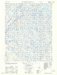
1962 Map of Beechey Point A-2
USGS Topo · Published 1962About this map
Foggy Island Bay dominates the northern coast of this Arctic landscape, where the Beaufort Sea meets the low-lying tundra of the North Slope. Surveyed by the Army Map Service in the late 1950s, the terrain is characterized by a complex network of thaw lakes and braided drainage systems. The Shaviovik River and Kadleroshilik River flow northward through this water-saturated plain, their shifting channels and sandbars meticulously documented by photogrammetric methods. A solitary Tractor Trail provides the only evidence of overland passage across the frozen marshes, marking a vital transportation route used for seasonal supply and exploration before the development of permanent infrastructure. This map captures the region in a transitional period, after initial coastal hydrography was established by the USC&GS but prior to the large-scale industrialization of the nearby oil fields.
Find a feature on this map
4 named features on this map. Tap any name to fly to it.
Don’t see what you’re looking for? This feature index may not catch every label — zoom into the map to look around manually.
Map Details
Editions of this 1962 Beechey Point A-2 Map
This is the sole edition of this map. No revisions or reprints were ever made.
Other maps of this area

1951 · Beechey Point
USGS Topo · 1:250,000

1951 · Sagavanirktok D-5
USGS Topo · 1:250,000

1955 · Beechey Point
USGS Topo · 1:250,000

1955 · Beechey Point B-2
USGS Topo · 1:63,360

1955 · Beechey Point B-1
USGS Topo · 1:63,360

1955 · Beechey Point A-1
USGS Topo · 1:63,360

1955 · Beechey Point A-2
USGS Topo · 1:63,360

1955 · Beechey Point A-3
USGS Topo · 1:63,360

1955 · Beechey Point B-3
USGS Topo · 1:63,360

1955 · Sagavanirktok D-3
USGS Topo · 1:63,360