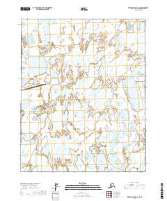
2017 Map of Beechey Point A-3 NE
USGS Topo · Published 2017About this map
Prudhoe Bay and the industrial hub of Deadhorse anchor this 2017 survey of Alaska's North Slope, a landscape dominated by braided river channels and the infrastructure of the American Arctic. The Sagavanirktok River winds through the center of the sheet, surrounded by countless small thaw lakes and tundra wetlands. As the northern terminus of the Dalton Highway, this area serves as a critical logistics point for petroleum operations, represented here by the Deadhorse Airport and localized road networks like Lake Colleen Drive E and Deadhorse Drive. The map illustrates the specialized development required for this environment, where large-scale human activity is concentrated along specific corridors amidst a complex hydrographic network of seasonal streams and permafrost features.
Find a feature on this map
11 named features on this map. Tap any name to fly to it.
Don’t see what you’re looking for? This feature index may not catch every label — zoom into the map to look around manually.
Map Details
Editions of this 2017 Beechey Point A-3 NE Map
This is the sole edition of this map. No revisions or reprints were ever made.
Other maps of this area

1951 · Beechey Point
USGS Topo · 1:250,000

1955 · Beechey Point
USGS Topo · 1:250,000

1955 · Beechey Point B-2
USGS Topo · 1:63,360

1955 · Beechey Point A-2
USGS Topo · 1:63,360

1955 · Beechey Point A-3
USGS Topo · 1:63,360

1955 · Beechey Point B-3
USGS Topo · 1:63,360

1960 · Beechey Point
USGS Topo · 1:250,000

1962 · Beechey Point B-2
USGS Topo · 1:50,000
1962 · Beechey Point A-2
USGS Topo · 1:50,000

1964 · Beechey Point
USGS Topo · 1:250,000