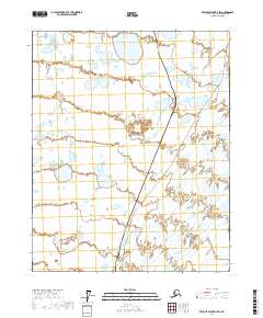
2017 Map of Beechey Point A-3 SW
USGS Topo · Published 2017About this map
The Sagavanirktok River meanders through this Arctic coastal plain landscape, defining the eastern portion of the terrain with its braided channels and wetland complex. This modern survey illustrates the critical infrastructure corridors that cross the North Slope, most notably the Alaska Pipeline and the adjacent Dalton Highway. These two features run nearly parallel through the center of the map, carving a straight path through the low-lying tundra and numerous small lake bodies. The map captures the industrial and logistical backbone of the region, where the primary focus is the movement of resources across the vast, open reaches of t9n r14e and t8n r14e.
Find a feature on this map
7 named features on this map. Tap any name to fly to it.
Don’t see what you’re looking for? This feature index may not catch every label — zoom into the map to look around manually.
Map Details
Editions of this 2017 Beechey Point A-3 SW Map
This is the sole edition of this map. No revisions or reprints were ever made.
Other maps of this area

1951 · Beechey Point
USGS Topo · 1:250,000

1951 · Sagavanirktok D-5
USGS Topo · 1:250,000

1955 · Beechey Point
USGS Topo · 1:250,000

1955 · Beechey Point A-3
USGS Topo · 1:63,360

1955 · Beechey Point A-4
USGS Topo · 1:63,360

1955 · Sagavanirktok D-3
USGS Topo · 1:63,360

1955 · Sagavanirktok D-4
USGS Topo · 1:63,360

1956 · Sagavanirktok
USGS Topo · 1:250,000

1958 · Sagavanirktok
USGS Topo · 1:250,000

1960 · Beechey Point
USGS Topo · 1:250,000