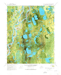
1970 Map of Beechey Point A-4 NE
USGS Topo · Published 1974About this map
The Kuparuk River and Tulugayuk River dominate this 1970 orthophotomap of the North Slope, revealing a complex landscape of thermokarst lakes and braided water channels during the peak of the Arctic summer. This specific edition, produced from aerial photography, captures the era of early oil exploration in northern Alaska, marked by the presence of Placid Et Al State No. 1. Unlike traditional topographic maps, this imagery-based study provides a direct view of the surface conditions, showing the intricate drainage patterns near landmarks like Hurl and Fresh. The reliance on a Winter Trail for transport highlights the seasonal nature of movement across this permafrost environment, where land lines remain largely unsurveyed by the Bureau of Land Management.
Find a feature on this map
8 named features on this map. Tap any name to fly to it.
Don’t see what you’re looking for? This feature index may not catch every label — zoom into the map to look around manually.
Map Details
Editions of this 1970 Beechey Point A-4 NE Map
2 editions found
Other maps of this area

1951 · Beechey Point
USGS Topo · 1:250,000

1955 · Beechey Point
USGS Topo · 1:250,000

1955 · Beechey Point B-4
USGS Topo · 1:63,360

1955 · Beechey Point A-3
USGS Topo · 1:63,360

1955 · Beechey Point A-4
USGS Topo · 1:63,360

1955 · Beechey Point B-3
USGS Topo · 1:63,360

1960 · Beechey Point
USGS Topo · 1:250,000

1962 · Beechey Point B-4
USGS Topo · 1:50,000

1964 · Beechey Point
USGS Topo · 1:250,000
1970 · Beechey Point A-4 NE
USGS Topo · 1:24,000