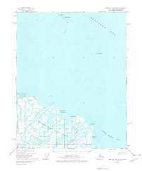
1955 Map of Beechey Point B-2
USGS Topo · Published 1978About this map
The Sagavanirktok River Delta dominates this mid-century coastal survey, revealing a complex network of braided channels where the Sagavanirktok (Main Channel) River meets the Beaufort Sea. This 1955 environment is documented just as early industrial exploration began to touch the North Slope, marked by early features like Sag Delta No 1 and several scattered Drill Hole locations across the wetlands and coastal islands. The landscape is a mix of transient landforms and established landmarks, from the shifting shoals of Dinkum Sands to more permanent features like Howe Island and Anxiety Point. Small Cabins represent the few signs of human habitation in this subarctic maritime environment, providing essential context for researchers of Arctic geography and the pre-development era of the Prudhoe Bay region. The map also traces the vast shoreline of Foggy Island Bay, anchoring locations such as Point Brower and Foggy Island within the larger coastal ecosystem.
Find a feature on this map
15 named features on this map. Tap any name to fly to it.
Don’t see what you’re looking for? This feature index may not catch every label — zoom into the map to look around manually.
Map Details
Editions of this 1955 Beechey Point B-2 Map
2 editions found
Other maps of this area

1951 · Beechey Point
USGS Topo · 1:250,000

1955 · Beechey Point
USGS Topo · 1:250,000

1955 · Beechey Point B-2
USGS Topo · 1:63,360

1955 · Beechey Point B-1
USGS Topo · 1:63,360

1955 · Beechey Point A-1
USGS Topo · 1:63,360

1955 · Beechey Point A-2
USGS Topo · 1:63,360

1955 · Beechey Point A-3
USGS Topo · 1:63,360

1955 · Beechey Point B-3
USGS Topo · 1:63,360

1960 · Beechey Point
USGS Topo · 1:250,000
1962 · Beechey Point A-1
USGS Topo · 1:50,000