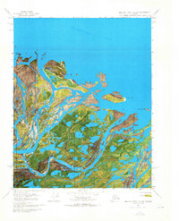
1970 Map of Beechey Point B-2 SW
USGS Topo · Published 1971About this map
Sagavanirktok River Delta dominates this coastal orthophotomap, showing the intricate network of river channels as they meeting the Beaufort Sea. The 1970 aerial imagery captures the industrial beginnings of the North Slope at the Sag Delta No 1 Oil Well, a solitary marker of resource exploration positioned near the coast. The landscape is a mosaic of tundra and shifting water, where the West Channel and Sagavanirktok River East Channel split around low-lying land masses such as Howe Island and Duck Island. A solitary Winter trail provides the only overland route through the delta, reflecting the extreme seasonal nature of Arctic travel. Features like Heald Point and Anxiety Point provide navigational reference along a shoreline defined by the constant movement of ice and silt at the river's mouth.
Find a feature on this map
15 named features on this map. Tap any name to fly to it.
Don’t see what you’re looking for? This feature index may not catch every label — zoom into the map to look around manually.
Map Details
Editions of this 1970 Beechey Point B-2 SW Map
2 editions found
Other maps of this area

1951 · Beechey Point
USGS Topo · 1:250,000

1955 · Beechey Point
USGS Topo · 1:250,000

1955 · Beechey Point B-2
USGS Topo · 1:63,360

1955 · Beechey Point A-2
USGS Topo · 1:63,360

1955 · Beechey Point A-3
USGS Topo · 1:63,360

1955 · Beechey Point B-3
USGS Topo · 1:63,360

1960 · Beechey Point
USGS Topo · 1:250,000

1962 · Beechey Point B-2
USGS Topo · 1:50,000
1962 · Beechey Point A-2
USGS Topo · 1:50,000

1964 · Beechey Point
USGS Topo · 1:250,000