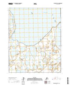
2017 Map of Beechey Point B-3 SE
USGS Topo · Published 2017About this map
Prudhoe Bay and the surrounding coastal tundra are the focus of this contemporary topographic study, showing the complex interface where the North Slope meets the Arctic Ocean. The shoreline is defined by the expansive Stefansson Sound to the north, with the Sagavanirktok River and Putuligayuk River carving through a landscape dominated by thaw lakes and wetlands. This map provides a detailed view of the coastal geography just offshore, including Gull Island and the Niakuk Islands. Further inland, the distinctive Prudhoe Mound stands as a notable relief feature on the otherwise flat, water-saturated plain. The survey reflects the modern industrial and environmental landscape of this vital energy region, documenting the hydrographic patterns of the rivers as they approach their deltaic outlets into the Beaufort Sea.
Find a feature on this map
13 named features on this map. Tap any name to fly to it.
Don’t see what you’re looking for? This feature index may not catch every label — zoom into the map to look around manually.
Map Details
Editions of this 2017 Beechey Point B-3 SE Map
This is the sole edition of this map. No revisions or reprints were ever made.
Other maps of this area

1951 · Beechey Point
USGS Topo · 1:250,000

1955 · Beechey Point
USGS Topo · 1:250,000

1955 · Beechey Point B-2
USGS Topo · 1:63,360

1955 · Beechey Point A-2
USGS Topo · 1:63,360

1955 · Beechey Point A-3
USGS Topo · 1:63,360

1955 · Beechey Point B-3
USGS Topo · 1:63,360

1960 · Beechey Point
USGS Topo · 1:250,000

1962 · Beechey Point B-2
USGS Topo · 1:50,000
1962 · Beechey Point A-2
USGS Topo · 1:50,000

1964 · Beechey Point
USGS Topo · 1:250,000