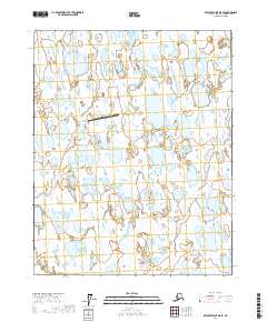
2017 Map of Beechey Point B-5 SE
USGS Topo · Published 2017About this map
The Ugnuravik River winds through the wetlands of the North Slope in this 2017 study, illustrating the hydraulic complexity of the Arctic coastal plain. The landscape is dominated by a dense network of thaw lakes and marshes, characteristic of the permafrost-influenced terrain near the Beaufort Sea. The presence of the Ugnu-Kuparuk Airport signifies the region's industrial importance, specifically its role in supporting the logistical needs of the North Slope oil fields. This survey provides a precise record of the shifting water bodies and the minimal infrastructure required to maintain operations in such a remote environment, where land and water merge into a seasonal mosaic.
Find a feature on this map
8 named features on this map. Tap any name to fly to it.
Don’t see what you’re looking for? This feature index may not catch every label — zoom into the map to look around manually.
Map Details
Editions of this 2017 Beechey Point B-5 SE Map
This is the sole edition of this map. No revisions or reprints were ever made.
Other maps of this area

1951 · Beechey Point
USGS Topo · 1:250,000

1955 · Beechey Point
USGS Topo · 1:250,000

1955 · Beechey Point B-4
USGS Topo · 1:63,360

1955 · Beechey Point A-5
USGS Topo · 1:63,360

1955 · Beechey Point A-4
USGS Topo · 1:63,360

1955 · Beechey Point B-5
USGS Topo · 1:63,360

1960 · Beechey Point
USGS Topo · 1:250,000

1962 · Beechey Point B-4
USGS Topo · 1:50,000

1964 · Beechey Point
USGS Topo · 1:250,000
2017 · Beechey Point A-5 NW
USGS Topo · 1:25,000