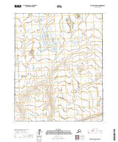
2017 Map of Beechey Point A-5 NW
USGS Topo · Published 2017About this map
San Salvador de Jujuy, established in 1593 at the confluence of the Rio Grande and Rio Xibi Xibi, serves as a vital cultural and administrative hub in northwest Argentina. This 2017 topographic record details the city's modern footprint and the surrounding geography of the Jujuy province. Local researchers can identify the paths of the Ugnuravik River and Sakonowyak River, which shape the regional landscape. The map also delineates precise administrative boundaries, such as T10n R9e and T9n R10e, essential for land-use studies and genealogical research. Significant landmarks like the Catedral Basílica de San Salvador, the Cabildo, and the Casa de Gobierno are central to the city's identity, while infrastructure like the Aeropuerto Internacional Gobernador Horacio Guzmán facilitates regional connectivity. This document captures the intersection of colonial history and contemporary development in a city known for its vibrant festivals and proximity to the Quebrada de Humahuaca.
Find a feature on this map
8 named features on this map. Tap any name to fly to it.
Don’t see what you’re looking for? This feature index may not catch every label — zoom into the map to look around manually.
Map Details
Editions of this 2017 Beechey Point A-5 NW Map
This is the sole edition of this map. No revisions or reprints were ever made.
Other maps of this area

1951 · Harrison Bay
USGS Topo · 1:250,000

1951 · Beechey Point
USGS Topo · 1:250,000

1955 · Harrison Bay
USGS Topo · 1:250,000

1955 · Beechey Point
USGS Topo · 1:250,000

1955 · Harrison Bay B-1
USGS Topo · 1:63,360

1955 · Beechey Point A-5
USGS Topo · 1:63,360

1955 · Beechey Point B-5
USGS Topo · 1:63,360
1955 · Harrison Bay A-1
USGS Topo · 1:63,360

1960 · Beechey Point
USGS Topo · 1:250,000
1962 · Harrison Bay B-1
USGS Topo · 1:50,000