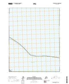
2017 Map of Beechey Point C-4 SE
USGS Topo · Published 2017About this map
The Beaufort Sea dominates the southern portion of this coastal survey, where the icy waters of the Arctic meet the low-lying shoreline of the North Slope Borough. Near the western edge of the sheet, Cottle Island sits just offshore, while the shallow waters are further defined by the presence of Cat Shoals to the north. The map documents the vast, unpopulated stretch of the Alaska coastline, defined largely by the intersection of the sea and the remote tundra of the North Slope. Surveyed in 2017, the map delineates several public land survey boundaries, including t14n r12e and t13n r12e, which provide a framework for navigating this otherwise featureless arctic landscape.
Find a feature on this map
8 named features on this map. Tap any name to fly to it.
Don’t see what you’re looking for? This feature index may not catch every label — zoom into the map to look around manually.
Map Details
Editions of this 2017 Beechey Point C-4 SE Map
This is the sole edition of this map. No revisions or reprints were ever made.
Other maps of this area

1951 · Beechey Point
USGS Topo · 1:250,000

1955 · Beechey Point
USGS Topo · 1:250,000
1955 · Beechey Point C-4
USGS Topo · 1:63,360

1955 · Beechey Point B-4
USGS Topo · 1:63,360

1955 · Beechey Point B-3
USGS Topo · 1:63,360

1960 · Beechey Point
USGS Topo · 1:250,000

1962 · Beechey Point B-4
USGS Topo · 1:50,000
1962 · Beechey Point C-4
USGS Topo · 1:50,000

1964 · Beechey Point
USGS Topo · 1:250,000
1970 · Beechey Point B-3 NW
USGS Topo · 1:24,000