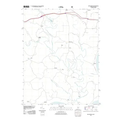
2010 Map of Beechwood
USGS Topo · Published 2010About this map
The winding Little Blue River and Turkey Fork define the rural topography of Crawford County in this 2010 study. Small crossroads communities and scattered homesteads like Beechwood, Jericho, and Sulphur Springs are connected by a network of local roads such as Mansfield Rd and S Riddle Rd. The presence of numerous family and church burial grounds, including Wiseman Cemetery, Birds Cemetery, and Orchard Hill Cemetery, provides significant documentation for genealogical research in this riverine landscape.
Find a feature on this map
40 named features on this map. Tap any name to fly to it.
Don’t see what you’re looking for? This feature index may not catch every label — zoom into the map to look around manually.
Map Details
Editions of this 2010 Beechwood Map
This is the sole edition of this map. No revisions or reprints were ever made.
Other maps of this area

1946 · Leavenworth
USGS Topo · 1:24,000

1947 · Leavenworth
USGS Topo · 1:24,000

1948 · Milltown
USGS Topo · 1:24,000

1950 · Beechwood
USGS Topo · 1:24,000

1950 · English
USGS Topo · 1:24,000
1950 · Leavenworth
USGS Topo · 1:24,000
1950 · New Amsterdam
USGS Topo · 1:24,000

1950 · Alton
USGS Topo · 1:62,500

1950 · Alton
USGS Topo · 1:24,000

1951 · Alton
USGS Topo · 1:24,000