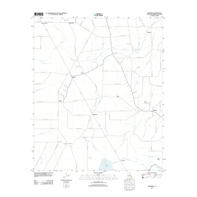
2012 Map of Beekman
USGS Topo · Published 2012About this map
Beekman sits at the heart of this Morehouse Parish landscape, defined by a network of rural settlements and industrial extraction. The Beekman Gas and Oil Field highlights the local energy economy, while the Stevenson Lookout Tower provides a strategic vantage point over the timbered lowlands. Water shapes the southern reaches of the quadrangle, where Bussy Brake, Ward Brake, and Pratt Brake create a complex wetland environment along Bayou Bartholomew. Smaller communities like Vaughn, Naff, and Humphreys are connected by a dense grid of named rural routes and timber trails, including Judge Barham TRL and Brother-In-Law TRL. Genealogists may find interest in the centrally located Stevenson Cem, which serves as a landmark for the surrounding family-named properties and dispersed settlements of the era.
Find a feature on this map
92 named features on this map. Tap any name to fly to it.
Don’t see what you’re looking for? This feature index may not catch every label — zoom into the map to look around manually.
Map Details
Editions of this 2012 Beekman Map
This is the sole edition of this map. No revisions or reprints were ever made.
Other maps of this area

1934 · Felsenthal
USGS Topo · 1:62,500

1935 · Naff
USGS Topo · 1:62,500

1935 · Haile
USGS Topo · 1:62,500

1937 · Felsenthal
USGS Topo · 1:62,500

1938 · Felsenthal
USGS Topo · 1:62,500

1939 · Felsenthal
USGS Topo · 1:62,500

1953 · Greenwood
USGS Topo · 1:250,000

1953 · El Dorado
USGS Topo · 1:250,000

1955 · Jackson
USGS Topo · 1:250,000

1955 · Shreveport
USGS Topo · 1:250,000