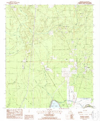
1998 Map of Beekman
USGS Topo · Published 1998About this map
Beekman and surrounding hamlets define the landscape of northern Morehouse Parish in this late 20th-century survey. The area is characterized by a complex network of waterways and depressions typical of the Louisiana lowlands, ranging from the prominent Bussy Brake and Bayou Bartholomew to smaller features like Snake Creek and Shiloh Slash. The map reveals a rural economy rooted in resource extraction, evidenced by an extensive Oil and Gas Field and a dense infrastructure of pipelines and transmission lines that cut through the terrain.
Find a feature on this map
45 named features on this map. Tap any name to fly to it.
Don’t see what you’re looking for? This feature index may not catch every label — zoom into the map to look around manually.
Map Details
Editions of this 1998 Beekman Map
This is the sole edition of this map. No revisions or reprints were ever made.
Other maps of this area

1934 · Felsenthal
USGS Topo · 1:62,500

1935 · Naff
USGS Topo · 1:62,500

1935 · Haile
USGS Topo · 1:62,500

1937 · Felsenthal
USGS Topo · 1:62,500

1938 · Felsenthal
USGS Topo · 1:62,500

1939 · Felsenthal
USGS Topo · 1:62,500

1953 · Greenwood
USGS Topo · 1:250,000

1953 · El Dorado
USGS Topo · 1:250,000

1955 · Jackson
USGS Topo · 1:250,000

1955 · Shreveport
USGS Topo · 1:250,000