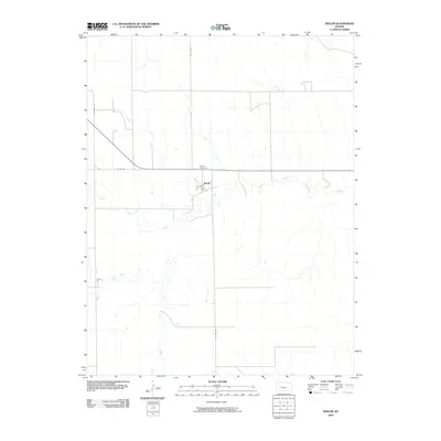
2009 Map of Beeler
USGS Topo · Published 2009About this map
Beeler sits at the heart of this Ness County landscape, where the local road network and prairie hydrology define the region's character. The settlement's layout is grounded by N Main and bounded to the north by the Beeler Cemetery, a key landmark for genealogical research in this part of Kansas. The surrounding terrain is shaped by the winding course of the South Fork Walnut Creek and its tributary, Darr Creek, which carve subtle drainage patterns across the agricultural grid. This 2009 survey by the U.S. Geological Survey illustrates a sparsely populated but organized rural environment, where major arteries like Lane-Ness Rd and W 130 Rd connect the isolated farmsteads and small communities typical of the High Plains.
Find a feature on this map
8 named features on this map. Tap any name to fly to it.
Don’t see what you’re looking for? This feature index may not catch every label — zoom into the map to look around manually.
Map Details
Editions of this 2009 Beeler Map
This is the sole edition of this map. No revisions or reprints were ever made.
Other maps of this area

1955 · Scott City
USGS Topo · 1:250,000

1958 · Scott City
USGS Topo · 1:250,000

1965 · Beeler
USGS Topo · 1:24,000

1965 · Utica SW
USGS Topo · 1:24,000

1966 · Laird
USGS Topo · 1:24,000

1966 · Utica SE
USGS Topo · 1:24,000
1974 · Beeler SE
USGS Topo · 1:24,000

1974 · Alamota
USGS Topo · 1:24,000

1974 · Beeler SW
USGS Topo · 1:24,000

1974 · Dighton SE
USGS Topo · 1:24,000