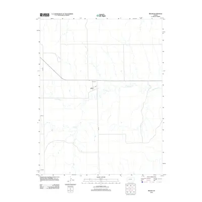
2012 Map of Beeler
USGS Topo · Published 2012About this map
Beeler sits as the central focal point in this landscape of the High Plains, situated along the sinuous path of S Fork Walnut Cr. The area is characterized by a sparse, grid-like road network, including north-south routes like Road 523 and east-west corridors such as Co Rd-110 and Co Rd-80. This 2012 survey illustrates the enduring agricultural layout of the region, where the Lane-Ness boundary marks the western edge of the quadrangle. For those tracing family ties to the area, the Beeler Cem is a prominent local landmark north of the town site. The drainage of Darr Cr feeds into the larger South Fork Walnut Creek system, highlighting the natural watercourses that dictated early settlement patterns in this part of western Kansas.
Find a feature on this map
8 named features on this map. Tap any name to fly to it.
Don’t see what you’re looking for? This feature index may not catch every label — zoom into the map to look around manually.
Map Details
Editions of this 2012 Beeler Map
This is the sole edition of this map. No revisions or reprints were ever made.
Other maps of this area

1955 · Scott City
USGS Topo · 1:250,000

1958 · Scott City
USGS Topo · 1:250,000

1965 · Beeler
USGS Topo · 1:24,000

1965 · Utica SW
USGS Topo · 1:24,000

1966 · Laird
USGS Topo · 1:24,000

1966 · Utica SE
USGS Topo · 1:24,000
1974 · Beeler SE
USGS Topo · 1:24,000

1974 · Alamota
USGS Topo · 1:24,000

1974 · Beeler SW
USGS Topo · 1:24,000

1974 · Dighton SE
USGS Topo · 1:24,000