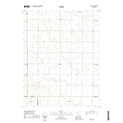
2018 Map of Beeler SW
USGS Topo · Published 2018About this map
The high plains of western Kansas converge where Finney, Ness, Lane, and Hodgeman counties meet in this detailed topographic record. The landscape is defined by the ephemeral drainage patterns of Plum Cr and Hackberry Cr, which carve subtle relief into the prairie. A primary point of interest for genealogists and local historians is the Buda Cem, a lone landmark in the southeastern portion of the map that anchors the area's agricultural past. The map reveals a strictly gridded network of section roads, such as Co RD 523 and W 40 RD, illustrating the persistent structure of the Public Land Survey System. In the northern reaches, the distinctive terrain of Guzzlers Gulch and the course of Spring Cr provide the only significant deviations from the flat upland plateau.
Find a feature on this map
28 named features on this map. Tap any name to fly to it.
Don’t see what you’re looking for? This feature index may not catch every label — zoom into the map to look around manually.
Map Details
Editions of this 2018 Beeler SW Map
This is the sole edition of this map. No revisions or reprints were ever made.
Other maps of this area

1955 · Scott City
USGS Topo · 1:250,000

1958 · Scott City
USGS Topo · 1:250,000

1965 · Beeler
USGS Topo · 1:24,000

1966 · Laird
USGS Topo · 1:24,000
1974 · Horse Thief Canyon NE
USGS Topo · 1:24,000
1974 · Beeler SE
USGS Topo · 1:24,000

1974 · Alamota
USGS Topo · 1:24,000

1974 · Hay Canyon
USGS Topo · 1:24,000

1974 · Beeler SW
USGS Topo · 1:24,000

1974 · Dighton SE
USGS Topo · 1:24,000