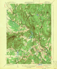
1943 Map of Belchertown
USGS Topo · Published 1943About this map
Belchertown and its surrounding hill country are defined by a complex intersection of early 20th-century institutions and transport corridors. The map highlights the sprawling grounds of the State School and the St Hyacinths Seminary, suggesting the area's significance for large-scale social and religious infrastructure during this period. Two major rail lines, the Central Vermont and the Boston and Maine, converge near the town center, cutting through a landscape of wetlands like Lawrence Swamp and high ridges including the Holyoke Range and Long Mountain. Local genealogy is well-supported by numerous burial grounds such as Lake Vale Cem, Rural Cem, and Munsel Cem. The terrain is punctuated by historic crossroads like Cooks Corner and Meads Corner, while bodies of water such as Metacomet Lake and Arcadia Lake indicate the region's diverse hydrology.
Find a feature on this map
59 named features on this map. Tap any name to fly to it.
Don’t see what you’re looking for? This feature index may not catch every label — zoom into the map to look around manually.
Map Details
Editions of this 1943 Belchertown Map
4 editions found
Other maps of this area

1885 · Northampton
USGS Topo · 1:62,500

1886 · Springfield
USGS Topo · 1:62,500

1886 · Northampton
USGS Topo · 1:62,500

1887 · Palmer
USGS Topo · 1:62,500

1887 · Belchertown
USGS Topo · 1:62,500

1889 · Springfield
USGS Topo · 1:62,500

1889 · Palmer
USGS Topo · 1:62,500

1890 · Belchertown
USGS Topo · 1:62,500

1891 · Northampton
USGS Topo · 1:62,500

1893 · Northampton
USGS Topo · 1:62,500