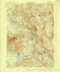
1943 Map of Belchertown
USGS Topo · Published 1943About this map
The town of Belchertown serves as the focal point for this early 1940s landscape, where two significant rail lines—the Boston and Maine and the Central Vermont—intersect amidst a complex network of ponds and wetlands. The map captures a high density of institutional and local landmarks, including the St Hyacinths Seminary and the State School. This era shows a community defined by its water resources and small outlying junctions like Dwight, Meads Corner, and Knights Corner.
Find a feature on this map
57 named features on this map. Tap any name to fly to it.
Don’t see what you’re looking for? This feature index may not catch every label — zoom into the map to look around manually.
Map Details
Editions of this 1943 Belchertown Map
4 editions found
Other maps of this area

1885 · Northampton
USGS Topo · 1:62,500

1886 · Springfield
USGS Topo · 1:62,500

1886 · Northampton
USGS Topo · 1:62,500

1887 · Palmer
USGS Topo · 1:62,500

1887 · Belchertown
USGS Topo · 1:62,500

1889 · Springfield
USGS Topo · 1:62,500

1889 · Palmer
USGS Topo · 1:62,500

1890 · Belchertown
USGS Topo · 1:62,500

1891 · Northampton
USGS Topo · 1:62,500

1893 · Northampton
USGS Topo · 1:62,500