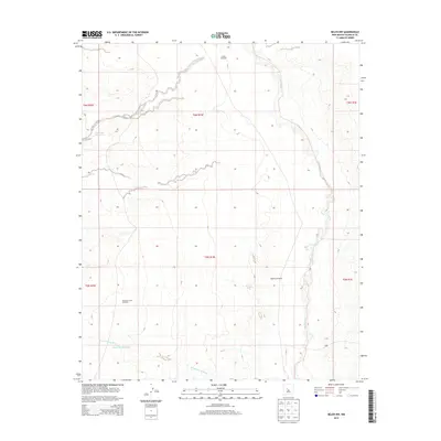
2013 Map of Belen NW
USGS Topo · Published 2013About this map
Rio Puerco defines the eastern boundary of this arid landscape, winding through Valencia County's high desert terrain. The area's reliance on water management and ranching infrastructure is evident through the placement of key resources like the Gabaladon Reservoir and Escondido Reservoir. These water sources, alongside the Arroyo Monte Belen, indicate a landscape shaped by seasonal flows and the needs of livestock in a dry environment. Scattered across the map are markers of human activity and survival, specifically noted by the Pueblo Windmill, Popalito Windmill, and Shearing Corral Windmill. These features suggest a history of grazing and ranching where isolated infrastructure was essential for maintaining homesteads and livestock. The map's grid-like organization into townships and ranges, such as t6n r1w and t5n r1w, underscores the systematic surveying of this Western territory into the modern era.
Find a feature on this map
13 named features on this map. Tap any name to fly to it.
Don’t see what you’re looking for? This feature index may not catch every label — zoom into the map to look around manually.
Map Details
Editions of this 2013 Belen NW Map
This is the sole edition of this map. No revisions or reprints were ever made.
Other maps of this area

1917 · Cerro Verde
USGS Topo · 1:125,000

1952 · Dalies
USGS Topo · 1:24,000

1952 · Belen SW
USGS Topo · 1:24,000

1952 · Belen
USGS Topo · 1:24,000

1952 · Veguita
USGS Topo · 1:24,000

1952 · Belen NW
USGS Topo · 1:24,000

1952 · Rio Puerco
USGS Topo · 1:24,000

1954 · South Garcia SE
USGS Topo · 1:24,000

1954 · Socorro
USGS Topo · 1:250,000

1956 · South Garcia
USGS Topo · 1:62,500