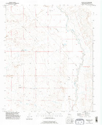
1991 Map of Belen NW
USGS Topo · Published 1996About this map
The Rio Puerco carves a winding path through this arid reach of Valencia County, defining a landscape shaped by historical land grants and livestock ranching. The eastern portion of the map is dominated by the Nicolas Duran de Chavez Grant and the Belen Grant, reflecting the region’s deep colonial and territorial heritage. Unlike more developed areas, this terrain is marked primarily by infrastructure for water and ranching, with remote outposts like the Shearing Corral and various fenced Corral sites.
Find a feature on this map
18 named features on this map. Tap any name to fly to it.
Don’t see what you’re looking for? This feature index may not catch every label — zoom into the map to look around manually.
Map Details
Editions of this 1991 Belen NW Map
This is the sole edition of this map. No revisions or reprints were ever made.
Other maps of this area

1917 · Cerro Verde
USGS Topo · 1:125,000

1952 · Dalies
USGS Topo · 1:24,000

1952 · Belen SW
USGS Topo · 1:24,000

1952 · Belen
USGS Topo · 1:24,000

1952 · Veguita
USGS Topo · 1:24,000

1952 · Belen NW
USGS Topo · 1:24,000

1952 · Rio Puerco
USGS Topo · 1:24,000

1954 · South Garcia SE
USGS Topo · 1:24,000

1954 · Socorro
USGS Topo · 1:250,000

1956 · South Garcia
USGS Topo · 1:62,500